

Our Study Area


The Blue Whale Study operates over different spatial scales depending on our research priorities
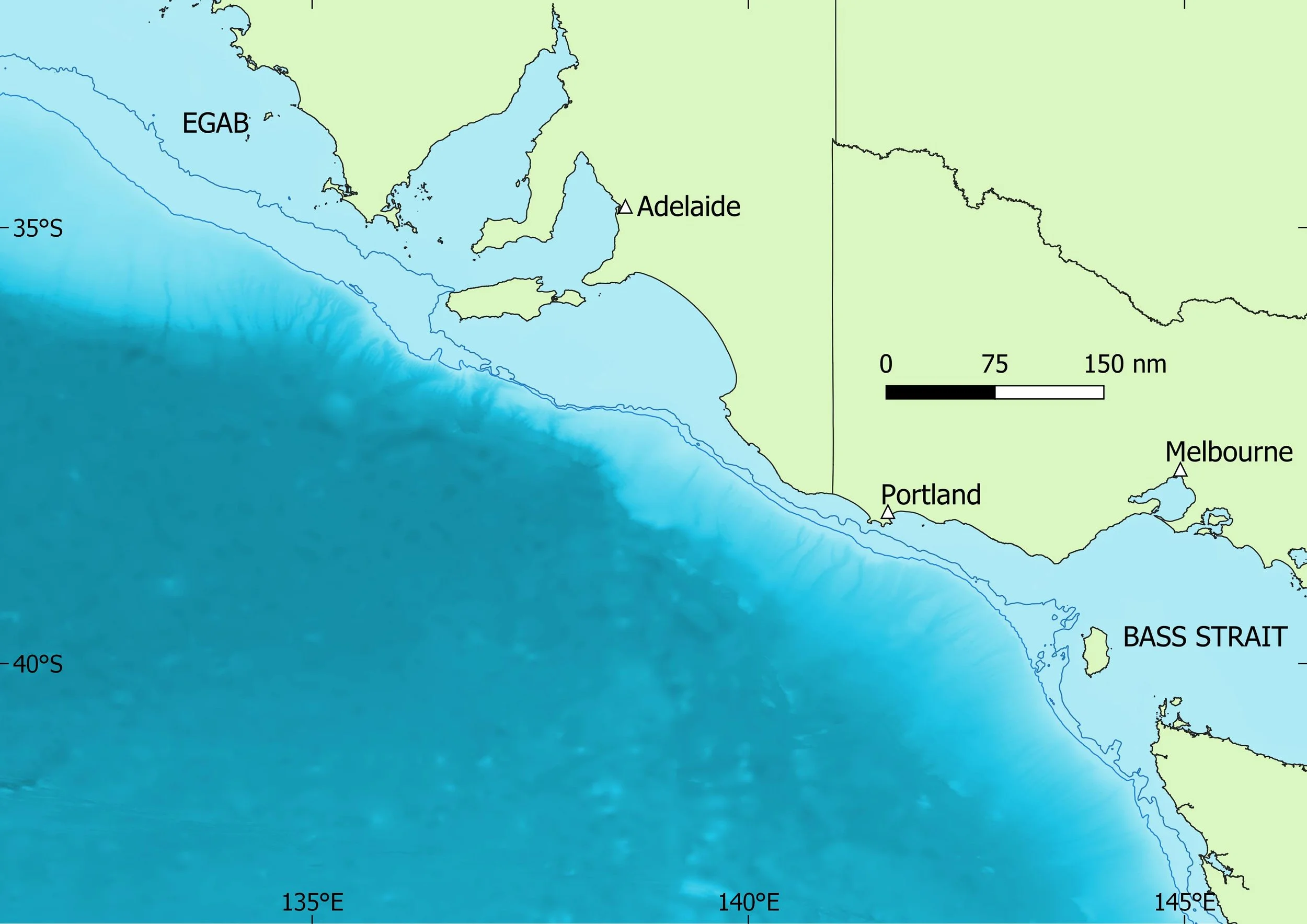
Our ‘large-scale study area’ covers the continental shelf and upper slope waters between 33°20’ S, 131°07’ E and 40°30’ S, 144° E, from the eastern Great Australian Bight to north-western Tasmania and western Bass Strait. The total area is approximately 63,000 km2. On an even larger scale, we are also interested in waters outside the continental shelf (and the influence of upwelling) to 41 degrees south and beyond, where pygmy blue whales forage along the Sub-Tropical Convergence. See Figure 1, below.
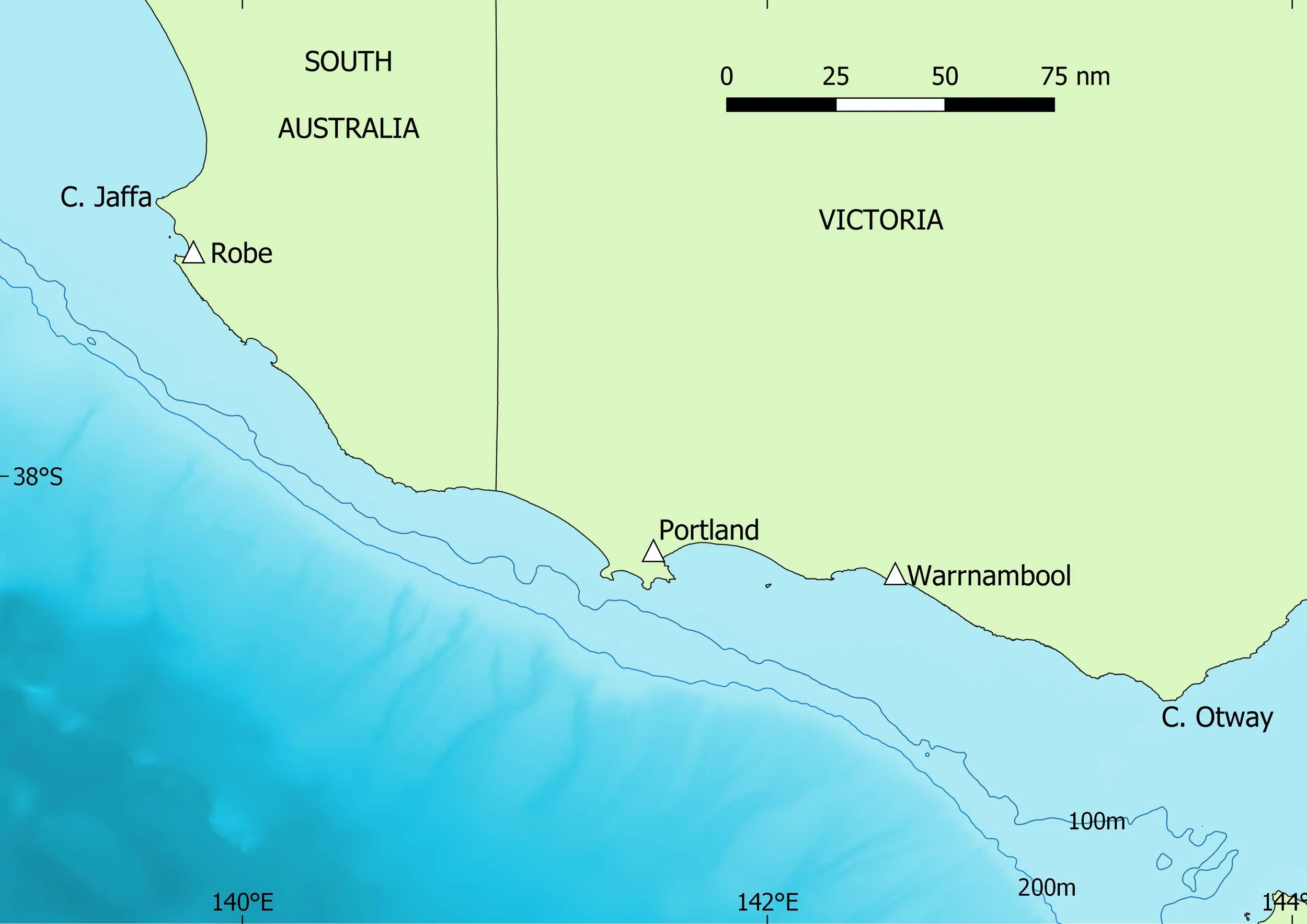
Our ‘core study area’, where most of our research activity has taken place, covers the whole of the continental shelf and upper slope from Robe, South Australia (37°09’S, 139°45’E), to Cape Otway, Victoria (38°52’S, 143°32’E), an area of approximately 21,000 km2 (see Figure 2 below). We usually use Portland as a base for aerial and boat-based research. The coast and shelf in the study area lie approximately along an ESE-WNW axis, a crucial alignment with the south-east winds that drive upwelling during the warmer months.
The continental shelf off south-east Australia is described as the ‘southern coastal boundary of the Australian mainland’ and has ‘a maximum width of 200 km in the central Great Australian Bight’ (Butler et al., 2002). The shelf narrows to about 20km along the Bonney Coast of South Australia and off Portland. The depth on the shelf in the Bonney Coast increases gradually out to 100 m where a distinct increase in steepness is then observed between 100m-200m. The continental slope and the abyssal plain (between 1,000 and 5,000 m) along the Eyre Peninsula and the Bonney Coast, are connected by over 20 very large and steep canyons, which are thought to be conduits for upwelling water (Middleton and Bye, 2007). The South Australian Basin, a major abyssal plain (depth 5,500 m) is located offshore, adjacent to the shelf region (Butler et al. 2002).
Figure 1: BWS 'large-scale study area'. EGAB = eastern Great Australian Bight. 100m and 200m depth contours shown.Figure 2: BWS ‘core study area’. 100m and 200m depth contours shown.
The primary driver of ocean upwelling is wind. Upwelling brings cool water toward the surface, though much upwelled water may remain below warmer surface layers. The surface ‘plume’ of the Bonney Upwelling is one of Australia’s most remarkable marine phenomena, extending westward along the continental shelf from Cape Nelson (141°30’E) to about 138°E. It is part of the Great Southern Australian Coastal Upwelling System (GSACUS) which extends approximately 800km from north-west Tasmania to the eastern Great Australian Bight. South-east winds displace warm surface waters offshore, to be replaced with cold water from deep in the Southern Ocean, bringing vast quantities of nutrients to the surface. This larger system is influenced by the Flinders Current, the world’s only northern boundary current.
Tiny plants, called phytoplankton, thrive on these upwelled nutrients. They in turn provide food for krill which attracts blue whales, baitfish and other diverse fauna. Krill live in the upwelling year round, but their numbers increase when abundant food is available during the upwelling season and their swarms grow bigger throughout the season.
Driven by south-east winds, this dynamic marine event intensifies around the start of November each year. Reflecting the presence of their prey, blue whales usually arrive at the start of the upwelling season to start feeding, and may remain until May. Upwelling intensity, krill abundance and blue whale abundance vary from year to year in response to climatic and oceanographic changes. Figure 1 below is a colour-coded satellite image of sea surface temperature. Red represents warmest temperature and blue the coolest. The thin black line in the image is the 200m isobath, the edge of the continental shelf.
References
A Butler, F Althaus, D Furlani, K Ridgway (2002). Report to Environment Australia. Assessment of the conservation values of the Bonney upwelling area. A component of the Commonwealth Marine Conservation Assessment Program 2002-2004.
Kaempf, J., M. Doubell, D. Griffin, R.L. Matthews, T.M. Ward (2004) Evidence of a large seasonal coastal upwelling system along the southern shelf of Australia. Geophysical Research Letters 31: L09310, doi:10.1029/2003GL019221
Kaempf, J. (2015) Phytoplankton blooms on the western shelf of Tasmania: evidence of a highly productive ecosystem. Ocean Science 11: 1-11. doi:10.5194/os-11-1-2015
Middleton JF and JAT Bye (2007) A review of the shelf-slope circulation along Australia’s southern shelves: Cape Leeuwin to Portland. Progress in Oceanography 75:1-41.
Levings, A.H. and P.C. Gill. 2010. Seasonal winds drive water temperature cycle and migration patterns of southern Australian giant crab Pseudocarcinus gigas. Pp. 461-478 In Biology and Management of Exploited Crab Populations under Climate Change, edited by G.H. Kruse, G.L. Eckert, R.J. Foy, R.N. Lipcius, B. Sainte-Marie, D.L. Stram, and D. Woodby, Alaska Sea Grant College Program, 2010.
Shute, A., J. Kaempf, M. Doubell, A. Redondo Rodriguez, L. Moller, R. Baring, M. Newman (2022) Variability of surface and subsurface phytoplankton blooms in a seasonal coastal upwelling system. Continental Shelf Research 246: 104832. https://doi.org/10.1016/j.csr.2022.104832
The Bonney Upwelling

Figure 3: Imagery of a major upwelling event within the BWS study area
The dark blue surface plume of the Bonney Upwelling is right of centre; weaker surface upwelling is evident along the coast west of Bass Strait, off the south-west corner of Kangaroo Island, and off the west coast of Eyre Peninsula. Sub-surface upwelling (not visible in satellite images) is almost continuous along the shelf from King Island to Kangaroo Island.
Image courtesy CSIRO.