
FACT FILE
The Bonney Upwelling
In general terms, upwellings are powerhouses of nutrient cycling. Driven by wind, the process of upwelling draws deep, nutrient-rich cold water upwards towards the ocean’s surface replacing the warmer, usually nutrient-depleted, surface water.
The nutrients in upwelled water are derived from marine organisms (both plant and animal) dying and sinking to the ocean floor. These nutrients are most abundant near coasts and river outlets but may be conveyed by currents great distances along the ocean floor, to be upwelled far from their source.

Freshly upwelled (green) water at Cape Bridgewater, Victoria.
Photo BWS
Nutrient-rich waters
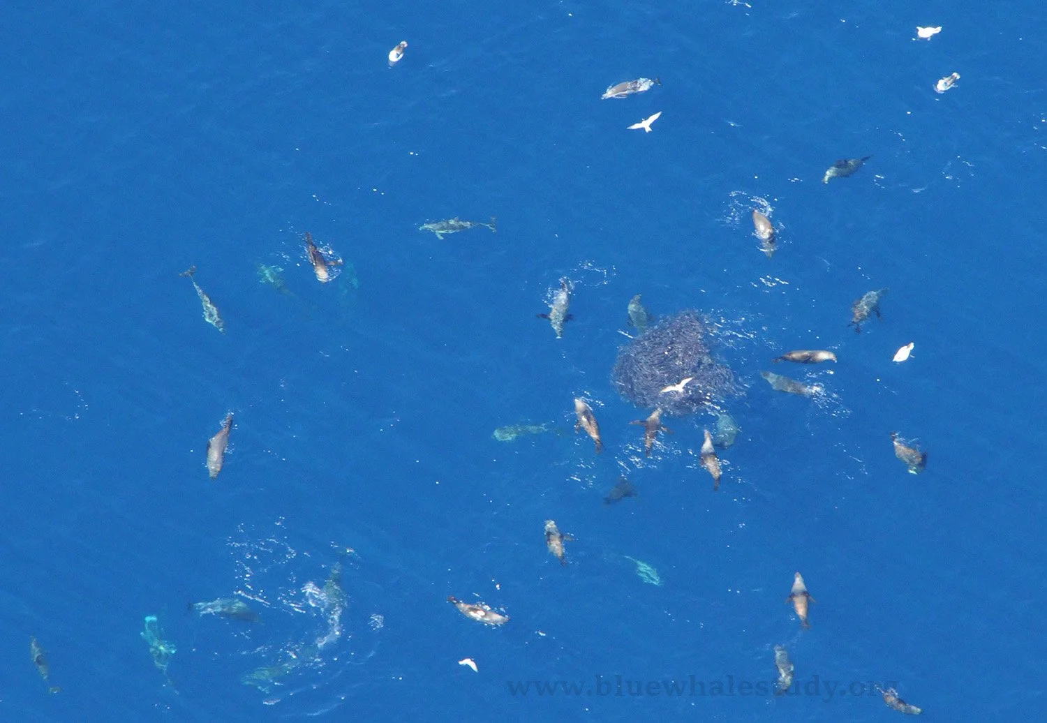
When upwelled nutrients meet sunlight near the surface, minute phytoplankton (plant-like cells) ‘bloom’, turning the ocean green and providing a vital food source for a range of animals from krill (small crustaceans) to small schooling fish. These feed larger animals including rock lobsters, giant crabs, fish (including commercial species), squid, seabirds, seals, dolphins and whales. Humans too are part of this complex food web, commercially fishing both krill (though not in our region) and the larger predators that feed on it.
Upwelling events may last from hours to weeks and are followed by ‘relaxation’ periods as winds calm or blow from other directions. Their timing and intensity varies from year to year. The right balance between upwelling and relaxation events is crucial to primary (phytoplankton) production. An upwelling season will be made up of multiple upwelling events.
A regional Australian upwelling system
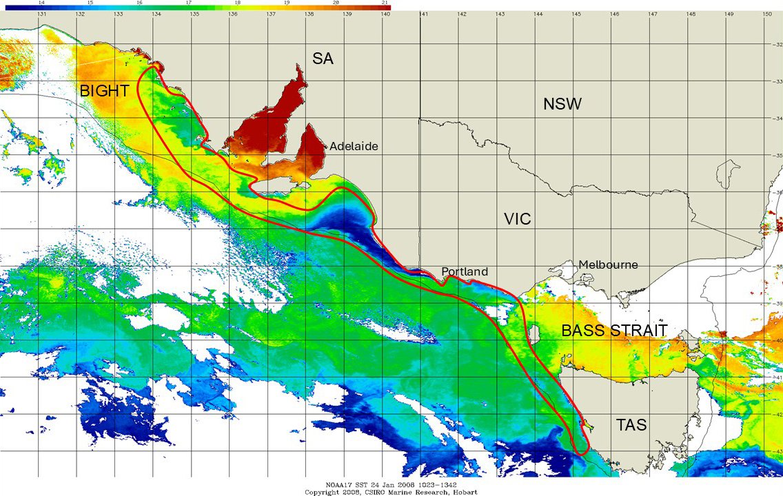
The satellite sea surface temperature (SST) image above shows the full extent of the Great Southern Australian Coastal Upwelling System (GSACUS), from north-west Tasmania to the eastern Great Australian Bight (area within the red outline). A temperature bar is seen at top (blue = coolest, red = warmest). It is important to remember that the GSACUS is the key ecological feature in the region, and blue whales feed along its extent, even where upwelling does not reach the surface (see image below).
The prominent blue plume at the centre of the image is the Bonney Upwelling, where upwelling is forced to the surface by the narrowness of the continental shelf. The narrower the shelf, the more intense the surface upwelling. It surfaces near Portland, Victoria, and extends west along the shelf past Robe, out toward Kangaroo Island. Elsewhere throughout most of the GSACUS, upwelling remains subsurface, although it can be just as productive as surface upwelling areas, which are also visible off Eyre Peninsula, south-west Kangaroo Island, between Portland and Cape Otway, and off the north-west coast of Tasmania.
Upwelling is driven by spring-summer (November to May) south-east winds associated with high pressure systems. These winds drive a current that flows north-west along the coast, until the earth’s Coriolis (rotational) effect deflects surface water away from the coast. This displaced warm surface water is replaced with cold, nutrient-rich Antarctic Intermediate Water that has travelled slowly across the Southern Ocean floor before being drawn onto the continental shelf through a series of submarine canyons. A number of upwelling centres associated with canyons and headlands merge into a continuous body of upwelled water that may remain in shelf waters for six months or more.

The distribution of about 1,500 blue whale sightings gathered by BWS between 1998-2016 is shown in the following map. Blue whales are a signature species of this upwelling system.
Threats to upwelling systems
Due to its importance as a blue whale feeding and aggregation site, the GSACUS has been nationally listed as critical habitat, and requires protection from user impacts.
As with all natural ecosystems, upwellings are susceptible to threatening processes. If human activities are wisely and sustainably managed, they pose no threat to natural systems. Such activities include fishing, oil and gas development, and military operations.
The potential for ecosystem collapse from overfishing is an ongoing issue Worldwide, upwelling systems provide 50% of the fisheries catch despite occupying only 1% of the ocean surface. While fishing must be regarded as a potential threat, at this stage fisheries in the GSACUS appear to be sustainably managed. The Bonney Upwelling currently sustains economically important commercial fisheries including rock lobster, bottom trawl, and squid fisheries, while in the eastern Great Australian Bight there is a major sardine fishery, as well as the southern bluefin tuna fishery. There was a proposal for a krill fishery in the Bonney Upwelling years ago but it did not eventuate.
An ongoing risk is posed by oil and gas exploration, with its associated issues of underwater noise, vessel movement and possibly catastrophic oil pollution. The upwelling region has been covered by seismic surveys over several decades, using percussive ‘airguns’ to map subsea geological structures. The map below was generated using data provided by Geoscience Australia, and shows 2D seismic surveys up to 2014. It is striking how closely the area most intensively surveyed aligns with the foraging habitat of pygmy blue whales. A major concern is that airgun frequencies closely overlap with blue whale communication frequencies, potentially displacing whales from preferred feeding areas and as has been recently discovered, having lethal effects on other key species such as krill.
Ship collisions are also a real threat for marine mammals including blue whales which have limited ability to avoid huge, fast-moving vessels that move daily along these coasts.
Climate change is probably the greatest threat to upwelling systems, as it is already changing the ocean’s circulation patterns, heat balance and ocean chemistry. Climatic events such as El Niño are increasing as the earth warms, and may influence the strength of upwelling, though whether they will intensify or diminish upwelling is now yet known; either way may have effects on marine productivity. The long-term effects of these changes may include major changes to upwelling systems, including increased acidification which is already becoming a major physiological challenge to many invertebrates including krill.


References
WW2010 University of Illinois, Department of Atmospheric Sciences. Upwelling: the transport of deeper water to shallow levels.
1998, Geerts, B., Ocean upwelling and phytoplankton. The SeaWiFs Project.
Middleton, J.F., C. Arthur, P. Van Ruth, T.M. Ward, J. McLean, M. Maltrud, P.Gill, A. Levings and S. Middleton. 2007. El Niño effects and upwelling off South Australia. Journal of Physical Oceanography 37(10): 2458-2477.
Gill, P.C., R. Pirzl, M.G. Morrice and K. Lawton. 2015. Cetacean diversity of the continental shelf and slope off southern Australia. Journal of Wildlife Management 79(4):672–681; DOI: 10.1002/jwmg.867
Wikipedia
https://en.wikipedia.org/wiki/Great_South_Australian_Coastal_Upwelling_System